
Information and data about Aldershot and Farnborough and our residents.
To understand Rushmoor and our residents better, we have put together some data sheets using key information.
The information is from a variety of sources, both internal and external, and where possible we have included a link to the actual data.
The age of the data varies, but we aim to update the data sheets when new information becomes available.
Rushmoor in numbers
- One borough
- Two world-famous towns
- 42,770 homes
- 105,750 residents
- 50.2% male, 49.8% female
- 2,840 military personnel and 370 civilian staff
- An average age of 38 years
- 39,056,390m2 of land
- 60% of land is green space
- 70 parks and playgrounds
- Four nature reserves and woodlands
- 3,490 businesses, providing 52,000 jobs
- 38 schools
- Two outstanding further education colleges
- Two arts and theatre centres
- Two indoor pools
- One lido
- Two football clubs
- One snow sports centre
- Three museums
- One world class conference and convention centre
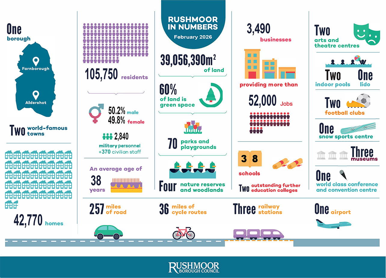
- 257 miles of road
- 36 miles of cycle routes
- Three railway stations
- One airport
Information about the people in Rushmoor
The following data sheets contain information about Aldershot's and Farnborough's residents:
- Population data sheet
- Age profile data sheet
- Ethnic diversity and migration data sheet
- Unemployment and benefits data sheet
- Education and skills data sheet
- Index of Multiple Deprivation 2025 data sheet
For information about the health of Rushmoor's residents, please see the Health profile for Rushmoor information on the Office for Health Improvement and Disparities website.
Information about living and working in Rushmoor
The following data sheets contain information about living and working in Aldershot and Farnborough:
- Businesses and employment data sheet
- Wage levels data sheet
- Housing data sheet
- Waste and recycling data sheet
For more information about the official labour market statistics for Rushmoor, please visit the Office for National Statistics' Nomis website.
2021 census data
You can find the 2021 census data on the Office for National Statistics' NOMIS website, which includes information about Rushmoor and the rest of the UK.
The Office for National Statistics have produced a build a custom area profile tool where you can view census data for different areas on a map. You can also create your own tables using the 2021 census tool, where you can search by different types of information, for example ethnic group.
Ward facts and figures
You can find more facts and figures at a ward level on our ward facts and figures page.
Contact us